-
V-TOL VEURON™ Awarded Ignite Ideas Grant
V-TOL is pleased to announce that it has been awarded an Ignite Ideas grant from the Advance QLD Fund by DSITI. The grant will be used to develop and test VEURON™ a technology designed to provide the on-board computing power necessary to enable real-time data analytics and a more sophisticated level of robot automation. “We…
-
V-TOL Conducts Multi-RPAS Multi-Task Multi-Sensor (MMM) Day/Night BVLOS Operations
Under its unique CASA & RAAF beyond visual line of sight (BVLOS) permissions, and building on its remotely piloted aircraft systems (RPAS) operational & manufacturing experience, V-TOL is now conducting day/night BVLOS multi-aircraft, multi-task, multi-sensor flight operations. The aim of this current RPAS flight program is to demonstrate the significant value RPAS can deliver into…
-
V-TOL Commences Routine Day/Night BVLOS Operations
V-TOL, under its unique CASA & RAAF permissions has commenced day & night beyond visual line of sight (BVLOS) unmanned aircraft (UA) flight operations at its 30km² Marburg Farm flight Area of Operations (AO) 10km NNW of RAAF Amberley. A testament to how routine these operations are viewed by RAAF operations, FA-18 Super Hornets…
-
The Nearing Future of Drones
The robotics and automation industry is rapidly emerging to be a key driver in the future growth strategies of global corporations. Drones are now at the forefront of our minds when it comes to technology. So where will drones be in five years? The benefits of employing these technologies across the ‘core’ economic sectors…
-
V-TOL Gains Drone/RPAS BVLOS Day Night Permission to Advance the Industry
V-TOL, a Queensland based Technology SME focusing on Unmanned Aircraft (UA) manufacturing, training and flight service operations has been issued a CASA Instrument to conduct day and night BVLOS (beyond visual line of sight) operations under its CASA ReOC 0074. This is a significant step towards routine advanced UA/Drone operations in support of Australia’s ‘core’…
-
CASA Sub 2kg Videos
New drone rules start today, allowing you to fly your sub 2kg drone commercially without the need to be certified, saving you both time and money. Before you take-off, you must complete an online notification form and agree to fly within the standard operating conditions to keep everyone safe. Your drone is your responsibility. Know…
-
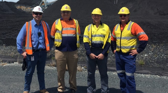
V-TOL & RelmaTech Prepare for World First at Port of Brisbane
Working with New Hope Group (NHG) staff members Martin Leggat & Tony Nielsen (on L), Mark Xavier (V-TOL) and John Thynne (RelmaTech UK), conduct the final risk assessment for RPAS survey operations over the Queensland Bulk Handling NHG facility at the Port of Brisbane. V-TOL has achieved a world first by securing the required permissions…
-
RelmaTech and V-TOL claim world’s first commercial RPAS/UTM flights
Secure airspace management for small drone operations is here RelmaTech’s SIAM system – the leader in making small drone operations safe BRISBANE, 22 August, 2016 – Australia’s V-TOL Aerospace has partnered with UK-based RelmaTech to conduct what they claim is the world’s first commercial flight operations of a remotely piloted airborne system (RPAS)…
-
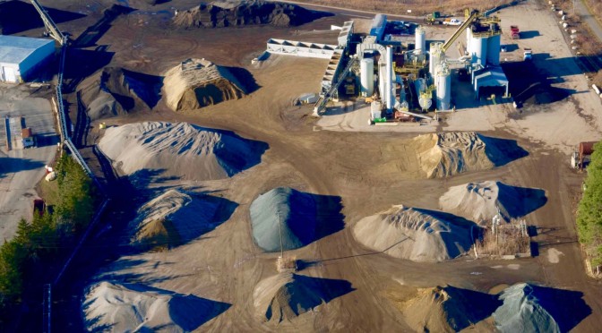
UAVs in Aggregates & Mining Part 2: Increasing Accuracy, Affordability, Safety and Speed
In Part 1 of our interview, Michael Singer, CEO of DroneView Technologies, talked through how drones have and will change volumetric measurement of stockpiles in the aggregates and mining industries. Michael also mentioned how UAVs can make things faster, cheaper, safer and more efficient for a project and even an entire organization, and now we’re going to…