In Part 1 of our interview, Michael Singer, CEO of DroneView Technologies, talked through how drones have and will change volumetric measurement of stockpiles in the aggregates and mining industries. Michael also mentioned how UAVs can make things faster, cheaper, safer and more efficient for a project and even an entire organization, and now we’re going to explore in detail how such things are possible.
In Part 2, we get specific in terms of how drones can make an impact on the bottom line for a project while also impacting critical areas like safety and efficiency. We also talk through the best approach when it comes to enabling adoption as well as discuss what can be the best way for mining professionals to move forward.
Making things more efficient while reducing costs is the sort of thing that sounds too good to be true, and you know what they say about such things. Since we’re talking about an industry whose scope and scale varies by company and region, what kind of an expectation should professionals have around drone efficiency and cost effectiveness?
Everyone is most interested in their own data and their own data points, and that’s a good thing. How a particular process or technology impacts Company X might not make one bit of a difference to Company Y, even if they’re in the same industry, and even if they offer the same kind of product or service. Everyone needs to understand the implications of change, and that comes in lots of different ways for people and processes, and it’s often based on how they’re already handling things.
For instance, if a company knows they have measured with laser once a year, they get comfortable with those volumes. If there’s a volume differential because they’re using a new tool, in this case aerial imaging with drones, they can in turn ask other questions. What are the implications of this to historical inventory? How are they going to deal with up or down changes that are the result of the implementation of this new tool? They need to understand and get comfortable with impacts like these, which are often subtle issues when we are moving forward with a client. Key questions like this will get raised from the financial office downward.
Can UAVs always be expected to make this kind of an impact?
Every organization is different, but if UAVs can be as accurate or better than LiDAR survey methods, cost considerably less than traditional survey methods, provide reports faster than what users have previously experienced and keep people from having to enter a dangerous situation, then we’re talking about a tool that can really have an impact on an operation no matter the size. And that kind of opportunity is here now.
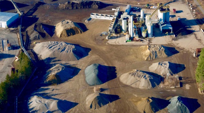
All right, but let’s talk specifics then. How exactly are UAV’s making professionals more accurate?
Many traditional tools are only able to gather information from a single perspective, and are inherently limited because of that. Granted, that perspective can still deliver very accurate scans, but UAVs enable operators to get additional accuracy in ways traditional tools cannot.
Regarding accuracy, where we’ve seen drones being potentially better is when you’re using laser from ground based capture, and you’re not able to easily see the top of stockpiles. That top might have geometry that’s important to the volume. The drone lets you see from the top down, so you have a more holistic view of whatever the target inventory you try to measure.
When you talk about drones being quicker, are you referring to the time it takes to pull, sort and process raw information and turn it into something people can use, or the time it takes to actually gather that data?
Both.
The quickness comes from the aerial acquisition of imaging data to processing to reporting. It’s the turnaround time from being boots on the ground and acquiring the data to delivering the report to whoever the constituent might be. We’ve refined the process such and we’ve found we can turn that around in 24 hours, and on very large sites 48 hours. That’s after seeing and hearing about many operations where turnaround times were much longer. It’s one area they’re seeing real benefit, particularly if they’re using fixed wing piloted aircraft where they then need to have that imaging processed.
As I said though, it’s not just about being faster in terms of getting the data though. It’s also about being faster in terms of moving forward with what you might want to do on a particular day, or for a particular task. Setting up a scan has typically been a process that can be cumbersome and needs to be laid out in detail before it can happen, which means it can’t happen as quickly. UAVs represent a means to gather info far quicker and easier without needing to setup laser stations.
What about safety? How do drones impact this area?
There are a couple points where the impact on safety is apparent. To the extent that professionals are using laser and are trying to climb on piles to capture laser shots not from the ground but on the piles somewhere, the potential for these piles to slide is very real and presents real danger. Sending a UAV to the top of that pile or at a position similar to where a person would be standing completely removes a person from that potentially dangerous situation.
The second element is that in all these mining operations you have large vehicles that move around with great regularity, and if you bring LIDAR or laser stations into these environments, you have people in the mix of operations for longer periods of times. Drones can be in that same environment with a takeoff and landing site that’s approximately 25 feet square and it’s impacted for 2-3 minutes at takeoff and again at landing. During the entire time the drone is flying you have little impact on the environment or to the operation, so you greatly reduce the amount of exposure points where you have people in potential harms way.
There are obviously expenses associated with drones, and when we’re talking about a tool that’s going to augment what someone is already doing, I have to think we’re also talking about additional costs, aren’t we? Are those costs offset by savings elsewhere?
What drones can do on a project to impact costs usually won’t be seen on a single line item, but there are a couple ways that we speak to it.
An important one is when a company is using a 3rd party for data collection. Let’s say they’re using fixed wing piloted aircraft today. Oftentimes, drone acquisition is outright less expensive and more flexible. That’s one element. Some of the downstream financial benefits are related to the ability to increase frequency, which goes back to the financial impact of measuring a stockpile on a monthly basis as opposed to doing it quarterly. We’re even hearing that some organizations want to do it more than once a month. So they find the value. Most are wanting a monthly cycle with certain episodic callouts when they have a need to see something off that cycle.
The thing to remember when we’re talking about costs is that the focus should really be around value. Companies can always go with the least expensive option when it comes to tools or processes, but if they don’t believe in the data it has no value. People have to appreciate the value, trust the value, see the safety impact, and then all wrapped together the absolute dollar cost tends to be lower. But a lower dollar cost with no confidence in the accuracy has little value.
So when you’re talking about a reduction in costs, you’re looking at that in a more holistic manner, correct?
All of these elements need to work together to really solve someone’s problem in terms of measuring the inventory, but then there are downstream values that come from it. Those are things like topography, mapping and surveying type work where you’re using these tools and software to accomplish tasks that used to take much longer and were typically more complicated. Such things can and do impact the bottom line.
So anyone who’s simply comparing the costs of a drone to the cost of a tool they’re currently using isn’t really looking at the issue in the right way, are they?
It’s certainly a very limited way thinking, because the across the board improvements are the thing that’s especially important to note and consider.
If we were just talking about reductions in cost or improvements in accuracy, it would be a much different conversation. You have to remember that all of these elements are tied together, because you can’t be faster without seeing improvements to your bottom line. You can’t be safer if you’re not able to get data that’s as good or better without using a different capture method. The benefits are there for people to recognize, which is why the approach organizations take around implementation is probably the biggest factors when it comes to successful adoption.
What are the biggest challenges you’re run into in this regard?
Having clients believe in the accuracy of the reported drone data and having them implement changes to established workflows and business processes.
Some of it is due to conflicting priorities. There are manufactures who want to convince people their product can and will make a difference in terms of the way to approach a project. There are service providers who tell you they can handle everything you need when it comes to the operation and implementation of a drone. And there are consultants who claim their advice is going to be the difference between success and failure. The challenge is that they’re all correct to different degrees and in different ways, which is further complicated by the fact that those manufacturers, service providers and consultants are themselves navigating the best way forward.
With the FAA issuing updates to their policies on a seemingly weekly basis and promises of Part 107 irrevocably changing the commercial landscape, professionals on every side of the conversation are constantly shifting their approach to best suit the needs of their clients and customers. Additionally, UAVs are a tool that can do anything from augment to replace an existing tool or process, and figuring out what’s going to work for a particular company or for a particular project can and should be considered on a case-by-case basis.
With those sorts of complications, how do you frame adoption to people who are interested but hesitant to really get involved?
It all comes back to the concept of value.
Every company measures their inventory in some way. Some are looking out the window to see a pile and after 25 years of doing this, they’re able to get an estimate that is accurate enough for their purposes. A drone will undoubtedly give that company better data about that stockpile, but if they’re unable or unwilling to do anything with the extra data, then what value does it have? All this data is only worth anything if it contributes to improving the way a company does things or if they’re learning from it to be more insightful, and taking action based on these insights.
We’re finding in some cases that companies that are accustomed to measuring their stockpiles once a year oftentimes experience significant material write-offs that can be up or down, in terms of changes to the expected inventory. They’re now able to capture these differences in something closer to real-time. Once they get going they’re oftentimes using this tool to measure more frequently, because they’re seeing value to capture the subtle changes with greater frequency. Those are the sorts of benefits that can be seen and achieved right now.
How will such things impact the way the industry as a whole views the technology?
If I were to try to gauge where adoption is right now, I’d say we’re still at single digit, 3-5%. Because of the things I’ve just laid out though, it’s our belief that in 2-3 years the industry will be at 60-70% adoption. Companies simply won’t be able to ignore the kind of benefits they’ll be able to see when they’re able to get data that makes everything they’re doing faster, cheaper, safer and more efficient. It’s really about them seeing and recognizing what’s already there, which makes this a very exciting time.
What’s the best way for a company or individual to enable this adoption?
You need to work with people who understand the technology, the business process and all of the elements of what’s required to achieve the desired result. That can be on a consulting basis where you want to bring the capability in house or use a trusted service provider to deliver the data. It’s really more complicated than going on Amazon and buying a drone.
What would you say to someone who is trying to figure out how drones can and should be utilized in their operation?
We’ve seen it time and time again where a company believes it’s going to be easy. They think they can just go out and buy a drone and do it, but the reality is that there are enough “gotchas” along the way that makes it a lot more complicated than people believe.
Whether you’re looking to consultants, service providers or the manufactures, there are means of support out there. It’s just a matter of figuring out how a UAV can provide you with the data that will make things faster, cheaper, safer and more efficient for a project or even an entire organization as a whole. The capability is there, it’s just a matter of implementation and integration.
About the Author
Jeremiah Karpowicz always envisioned a career as a screenwriter, but found the autonomy and freedom he was looking for in the digital space. He has created articles, videos, newsletters, ebooks and plenty more for various communities as a contributor and editor. He has also worked as the Executive Editor for ProVideo Coalition where he was first introduced to UAV technology. You can get in touch with him on Twitter: @jeremiahkarp